Nationwide guidelines on outdoor areas
On this page
- Accessible construction guidelines (SuRaKu)
- Accessibility on nature trails
- Accessible rail station infrastructure
Accessible construction guidelines (SuRaKu)
The accessible construction SuRaKu guidelines contain accessibility guidelines for designing, building and maintaining streets, green areas and yards. The practical guidelines were created through collaboration between the cities of Helsinki, Espoo, Joensuu, Tampere, Turku and Vantaa in 2004. The work instructions were finished under the management of the Helsinki for All project and with support from the Ministry of Social Affairs and Health.
The SuRaKu guidelines formed the foundation for the City of Helsinki’s accessibility plan. They are also freely available to other municipalities, communities and planners. The instructions contain a set of criteria, with which the accessibility of outdoor areas can be assessed, as well as instruction cards for the criteria’s practical application.
SuRaKu Instruction Cards
- Pedestrian crossings and pavements (pdf)
- Pedestrian streets and squares (pdf)
- Differences in elevation (pdf)
- Public courtyards (pdf)
- Park paths and resting places (pdf)
- Public playgrounds (pdf)
- Public bus stop areas (pdf)
- Temporary traffic arrangements (pdf)
SuRaKu Accessibility Criteria
- Kerbstones at pedestrian crossings (pdf)
- Outdoor staircases (pdf)
- Ramps (pdf)
- Guidance paving flags (pdf)
- Demarcation strips (pdf)
- Loading islands (pdf)
- Gutters and gullies (pdf)
- Walking surfaces (pdf)
- Pedestrian crossing markings (pdf)
- Handrails (pdf)
- Railings (pdf)
- Pedestrian push-buttons posts (pdf)
- Pedestrian crossing signs (pdf)
- Seating (pdf)
- Bollards in pedestrian zones (pdf)
- Pedestrian refuge islands (pdf)
- Tactile maps and information signboards (pdf)
- Warning areas (pdf)
SuRaKu update 2022
In the 2022 update, the text and images of the SuRaKu cards and the accessibility criteria were amended. The amendments took the new and updated decrees and regulations into account.
SuRaKu update 2008
The SuRaKu cards and the accessibility criteria were updated in 2008. The updates mainly consisted of clarifications to the 2004 guidelines. Some of the images were also completely changed.
Guide
- Mapping and evaluation guide for accessibility of outdoor locations (pdf, in Finnish)
- Guide cover (pdf)
The illustrated guide explains about pedestrian accessibility. It is suitable both as a check list and as study material.
The City of Helsinki’s type drawings for street areas
The accessibility solution principles have been included in the City of Helsinki’s type drawings for street areas (in Finnish), in accordance with the guidelines determined in the SuRaKu project.
Accessibility on nature trails
In addition to that, another mapping method, Luonto-ESKEH, was developed in 2014 for mapping nature trails.
Accessible rail station infrastructure
SUJUVA is a set of visualised accessibility regulations, guidelines and recommendations for designing accessible rail station infrastructure. It benefits designers, developers and maintenance providers alike. The objective is to provide straightforward and user-friendly visualised accessibility guidance to make it easier for designers to find the most effective accessibility solutions and to help maintenance providers to keep the infrastructure accessible at all times.
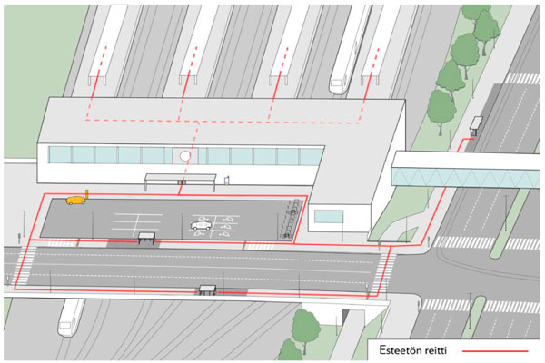
Rail station infrastructure is subject to special accessibility requirements and encompasses the metro or train station itself, including any buildings, as well as accessible routes to the nearest public transport connections, pick-up and drop-off points, and car parks.